Why Are Drones a Key Technology for Improving Onsite Construction Efficiency?
Drone technology may be among the most obvious Modern Methods of Construction (MMC) on the surface – but the benefits of using drones are more decisive than the fanfare of robots in the sky suggests. Augmented site surveying and mapping save engineers and builders time and money while improving safety for onsite personnel.
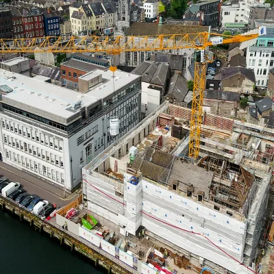
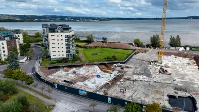
A whirring sound passes over the building site. Engineers and crews on the ground see a drone whizzing overhead, capturing high-quality imagery, generating topographical maps, measuring object distances, rendering 3D site models, and more. This is done quickly, efficiently, and with a small team of Drone Operators to set the site and pilot the device(s).
It’s easy to see why drones are held up as a poster child of the move to greater adoption of Modern Methods of Construction (MMC). But drones aren’t just flashy equipment used to deliver nice photographs. Engineers and specialist contractors around Ireland are mastering the use of this technology, capturing valuable site data and processing it for the use of teams onsite to help more efficient assembly and installation of building systems.
What are the uses and benefits of drone technology in construction? As mentioned, drones capture onsite imagery and videos to map topography, assess the condition and thermal performance of existing structures, monitor equipment, track project progress, measure distances, and generate digital site models. These crucial onsite tasks can be completed in a shorter time than it would take teams on foot to complete. Drones also generate data that can’t be captured from the ground and can negate the need for working at height.
Bob Foley, Director & Accountable Manager at Engineers With Drones, and Richard Coleman, Managing Director at Drone Solutions Ireland, both use the technology in day-to-day operations.
Bob says that drones are simply another tool in the extensive toolbox of a Site Engineer.

“There is a reason ‘Engineers’ is in our title before ‘Drones’. Engineers aren’t impressed by technology for the sake of it or high-quality pictures of a site that don't actually tell you anything. Drones are a useful tool for generating all kinds of data. But they are only a tool, same as any other an engineer uses onsite. What’s key is that engineers can harness data to generate insights making works more efficient.”
Director & Accountable Manager at Engineers With Drones
Bob refers to a project that Engineers with Drones worked on for Cork City Council illustrating these benefits. Engineers with Drones was contracted to assist an electrical installation services firm fitting new bulbs, wiring, switch boxes, and other public lighting infrastructure for a housing development in Co. Cork. The Council wanted to monitor the project and assess the impact on the footpaths and roads during and after alterations.

Engineers with Drones flew 200+ orthophoto missions, capturing on highly accurate topographical maps the exact position of existing infrastructure to assess the quality of installation after the project was completed. The team also overlayed 2D CAD imagery on the orthodata map to outline the location of new electrical infrastructure. These tasks used to be done on foot with engineers writing notes, taking pictures, and using measuring tools. This data coordination saved the Council dozens of hours in surveying on the ground.
For Bob, hiring the right type of construction professional for these projects is vital.
“I often turn away drone enthusiasts from roles with us because they don’t have a relevant engineering qualification, or any experience in construction. We hire technical people who understand the data recorded onsite and can interpret and act on it for the benefit of the client, and then train them in how to use drones.”
Director & Accountable Manager at Engineers With Drones
Engineers With Drones operates a Specific Category Licence which can only be attained by achieving an A1 qualification from the Irish Aviation Authority (IAA). Other training providers can offer A2 courses which, while useful in giving construction professionals grounding in technical drone operation, Bob says leaves ‘a major gap in technical skills’.
“In general, I think one of the biggest skills gap we can see around construction, engineering, and drone operation is in data interpretation. An orientation course to the different types of construction data, such as orthodata and Digital Terrain Models, as well as data management and analysis, would really benefit the sector.”
Director & Accountable Manager at Engineers With Drones
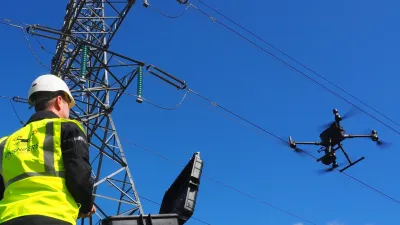
Richard Coleman, Managing Director at Drone Solutions Ireland, approaches the business of drones in construction as a pilot with a decade’s worth of experience. In that time, he has witnessed the evolution of drone technology from a niche capability into an essential tool for digital construction and infrastructure management.

With Drone Solutions Ireland, Richard specialises in digital construction surveying, geospatial data capture, photogrammetry, asset intelligence and drone-enabled project monitoring for property, construction, and infrastructure projects in Ireland and Europe. This helps clients improve safety, reduce survey times, and make smarter decisions.
Operating under European Union Aviation Safety Agency and IAA regulations in the Specific Category, Richard delivers complex drone operations and high-accuracy data acquisition services for engineering, construction and infrastructure projects. He believes the true value of drones lies not in the aircraft themselves, but in the quality of data they provide.
“I established Drone Solutions Ireland after recognising a growing need in the construction sector for accurate, reliable digital data rather than simply aerial imagery. It became clear to me that many construction and property companies were not lacking access to drones – they were lacking access to accurate, actionable information. The real value of drone technology lies in transforming captured data into meaningful outputs such as survey-grade maps, orthomosaics, 3D models, volumetric calculations, inspection datasets and digital records that support planning, delivery and asset management.”
Managing Director at Drone Solutions Ireland
He expanded further on this point:
“Supported by Enterprise Ireland, Drone Solutions Ireland has developed a technology-driven approach that combines advanced drone operations, survey-grade mapping and digital data workflows to help clients enhance safety, reduce survey times, and make more informed decisions throughout the project lifecycle.”
Managing Director at Drone Solutions Ireland
Drone technology is already delivering measurable benefits across the construction sector. Survey work that once required several days onsite can often be completed in hours, while aerial progress monitoring provides stakeholders with accurate and up-to-date records of project development. Drone-based inspections also reduce the need for personnel to work at height, improving safety and reducing operational risk.
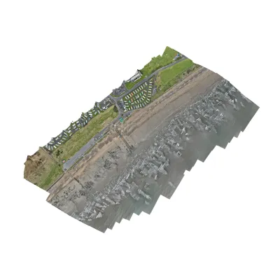
One example of this approach was Drone Solutions Ireland's involvement in the early phases of the Celtic Interconnector project, an electrical interconnection between Ireland and France to allow the exchange of electricity between the two countries.
Using drone photogrammetry combined with Ground Control Points (GCPs), the company delivered survey-grade orthomosaic mapping and highly accurate geospatial datasets suitable for engineering and construction workflows.
By integrating precisely surveyed control points with aerial data capture, Drone Solutions Ireland provided reliable digital intelligence while significantly reducing timescales compared to traditional surveying. The project demonstrated how drones can support large-scale infrastructure development through accurate, data-driven decision-making.
Beyond his IAA Specific Category Licence, Richard has received support from Cork Education &Training Board in Auto CAD, to augment drone imagery with digital building designs. By combining survey-grade aerial data with engineering and construction data, Drone Solutions Ireland helps clients improve project planning, progress monitoring, and asset management through accurate digital intelligence. This is a valuable area where Richard would like to identify new skills for the organisation.
“I would love to hire someone with Auto CAD skills for tasks such as digital design and document control. We can help people get the required aviation certifications and train people to operate drones. The most valuable skills to the industry are the ability to process, interpret and manage construction data, integrate outputs into engineering workflows, and help clients turn data into better project outcomes.”
Managing Director at Drone Solutions Ireland
Richard believes the future of drone technology in construction lies in its integration with Building Information Modelling (BIM), digital twins, and asset management systems.
“The conversation has moved beyond flying drones. Drones are now a critical data acquisition tool in the wider digital construction ecosystem. The real opportunity is in how construction teams manage, analyse and integrate information into project workflows to improve planning, collaboration, safety and project outcomes.”
Managing Director at Drone Solutions Ireland
As the construction industry continues to embrace digital transformation and MMC, the demand for high-quality spatial data and digital project information is increasing. This is led by a focus on digital surveying, geospatial data processing, CAD, BIM coordination, 3D modelling, and information management. Richard sees significant opportunities for professionals combining technical expertise with these digital construction skills.
When we reach a future where the sight of drones above construction sites is as common as planes in the sky remains a matter of industry uptake. The benefits of greater oversight and faster surveying for more efficient onsite assembly and installation are there waiting.
Related
-
 ICF – Lighter, Easier, and Faster Installation Using Ireland’s Most Popular Construction Material
 -
 Is Low-Carbon EPS Insulation Key to Developing More Sustainable Housing? And How Do Companies Develop the Right Skillsets?
 -
 How Can Digital Design and Offsite Manufacturing Maximise the Value of M&E Engineering?